** Beaufort, SC to Morehead City, NC **
This leg of our journey certainly magnified the difference in terrain along the Intracoastal Waterway (ICW) in the Carolina’s. We started with the marshes of low country, through the city of Charleston, into the beautiful winding woods that lined the banks of the Waccamaw River, straight into the cut of densely populated Myrtle Beach, turned North at Southport and followed the port lined banks of the Cape Fear River to Wilmington, then along the secluded North Carolina Shore by a marine base, and into a town with a big fishing problem. The tides are still ruling our travel.

Our voyage from Beaufort, SC to Morehead City, NC
In the vast majority of locations on Earth, the tides are governed by the pull of gravity from the moon. Published tidal tables are based on the lunar cycle and are predictions of when the high and low tides will occur for any given area, along with what the expected rise and fall of the water levels should be. They are surprisingly accurate in both areas, almost without exception. However, the predictions can be skewed a bit, as in a few places, such as the large sounds of Carolina, the effects of wind direction and velocity will overpower the lunar influences at play. In the area we traveled the rises and falls of water levels can be influenced by weather. Prolonged periods of strong winds can, literally, shove the water in the sounds and rivers around, causing rises or falls of water that can be measured in feet.

Ship Wreck
Part of our trip planning is being keenly aware of what is happening with the tide at the times of expected arrivals or departures at an inlet, shoaled area, marina, anchorage, etc. The expression ‘go with the flow’ came from the days of engineless sailing ships awaiting an outgoing tide before departing from a port.
Departing Lady’s Island, we were serenaded with our country’s finest, flying just above, performing maneuvers. We cruised below them for miles listening to the roar of the engines and watching them dart along the water. Thankful these men and women are willing to serve our country.
With no particular anchorage in mind, aiming for somewhere south of Charleston, we would cruise until we were ready to hang it up for the night. Arriving at the last decent anchorage area before Charleston in early afternoon, we knew we had more go in us. Continuing committed us cruising beyond Charleston and at least a 70 mile day. The winds were not in our favor and once we motored past Charleston, low tide had crept upon us. Not our best thinking to have ignored our pre Charleston anchorage plan. The anchorages we found north of Charleston were in the marshes with little to no wind protection, and shoaling at the entries, along with low tide made our first two locations no goes after several attempts, and maybe we just had to crawl off a shoal, just maybe.


The house in the middle of nowhere only accessible by boat, Charleston bridge
The sun was creeping fast towards the horizon, and after 12 hours on the water, our crew was a bit weary. Fellow loopers we had met in St. Mary’s, GA were a few miles ahead in what looked to be a good anchorage (we thought that about the last two), we messaged them, they indicated there was plenty of room and water if we could get over the hump and the entrance. With the sky turning darker, we slowly maneuvered up the ICW weaving in and out of skinny water and after two attempts to get over/through the hump, we made it and were able to set anchor. The only trees in sight for miles lined the riverbank on the west, protecting us from the winds howling from the west. Just over 12 hours, 97 miles, and a lot of white knuckle moments, the anchor was set just in time to watch the sun disappear. Sometimes we forget this is pleasure boating.

Anchor set just before sunset
There were times throughout the late afternoon and evening Tasha wanted to use the line – I’m tired, we’re coming in! But along the low tide banks of the waterway there was no way to get to a dock, everyone’s docks were dry near low tide. Imagine spending a few million for a beautiful home and dock and not having full access to your boat because of tides.


Low tide on the beach
The line – “I’m tired, we’re coming in” is one Tasha likes to repeat often and is linked to a gathering of boaters telling tales last year in Hilton Head. One first mate indicated they had a long day of cruising in south Florida (think mega million mansions). She had just enough for the day and saw a man out on his dock with plenty of room and yelled to him, “I’m tired, we’re coming in!” Pointed to the dock, her captain took them in. The man a bit in shock and wondering who this insistent woman was, grabbed the lines and tied them off. She took what she had made for dinner and a bottle, and they broke bread with the man on his patio. They became fast friends and stop at his dock each time they transit south Florida. Now it may have helped that they are on a classic, beautiful 85’ Burger. Not sure how the 44’ Carver would be accepted with that line. Maybe a visit from the local sheriff? One of these days, Tasha’s might just try it.


Wacca Wache Marina
With a fifty four mile cruise the next day, we tied up at Wacca Wache Marina in Murrells Inlet, SC with some of the best diesel prices, $3.55/gallon. The transient dock was just behind the fuel dock on the river side by the restaurant. A very quiet, protected marina lies behind the back. We got in early and spent the day watching the boats go by on the Waccamaw River and enjoyed a front row seat to the band that played that night to a full house. They played from 5 – 8, courteous of our early bedtime.


Beautiful Waccamaw River
We would endure a 61 mile voyage the following day through Myrtle Beach, on a weekend, and conquer the dreaded rock pile. What were we thinking? We were off before seven and the serene quiet Waccamaw River was breath taking. This part of the river reminds us a lot of our home waters of the Ohio and the inland rivers. We had the river to ourselves and marveled in the beautiful reflections along the river. It was breathtaking. The only action we saw on the Waccamaw was late in the morning, cruising by the “party” boat as we did last year. Being a Saturday, they were open this time serving up food and drinks boat to boat. We were a little too big to pull up and they were in too shallow of water for us.


Party Boat
The Waccamaw led way to a very narrow cut of the ICW through Myrtle Beach and tons of pleasure boat traffic. The shore is lined with new construction, box house, after box house. A stark contrast from the beautiful woods we just cruised through. One of the less scenic areas of the trip. We managed to get to the rock pile by noon with two other larger boats in front of us a mile or so. The rock pile is a three mile long stretch of the ICW that was cut from granite to make a very narrow channel for boats to transit. If you steer too far to port or starboard, there is a ledge of granite just a few feet under the surface of the water that will tear your boat up. If there is a large boat or barge coming from the opposite direction, well, that’s not good. Standard practice is to announce yourself on the marine radio prior to entering the narrow channel because no one wants to turn around or even attempt to back out. We encountered one sailboat, and we passed slowly port to port, very close to one another.


Rows of houses in Myrtyle Beach, not much notice for Rock Pile, passing sailboat in Rock Pile
Making it through the rock pile unscathed we had 25 miles further to reach the Holden Beach transient dock for the night. The 25 miles took double our normal time with tons of traffic and no wake zones. The Holden Beach dock is a 90 foot lay along with one power pedestal. Enough room for two boats our size. Being the weekend we were to check in and pay at the police department. No one was there, so we called the non-emergency number to be told to call 9-1-1. Hmm, that’s a hard one for a former Sheriff and Chief, you never want people calling 9-1-1 for a non-emergency but he did. Dispatch took our information and 3 minutes later an officer comes out the front door to greet us. We were told if needed anything during our visit, call 9-1-1. Much more casual with their 9-1-1 than we are used to.
We walked to the beach and the coffee shop the following morning. Holden Beach seems to be a vacation island, not much other than a beautiful beach and private homes and rentals. The dock was perfect for what we needed, a good, safe, stopping point.


Holden Beach, NC
As we transit north, on familiar waters, we are consciously looking for new ports, anchorages to visit. Though some, just keep calling us back, and one is Southport, NC. We docked at a different marina this time, a few miles from the heart of the city, in the same port where the Bald Head Island Ferry departs. WOW! What a ferry terminal, the nicest we’ve ever seen.


Bald Head Island Ferry Landing at Deep Point Marina
Being a bit on the out skirts, we unfolded our bikes and were able to see more of this seaside village we are so fond of. Visiting our exclusive club for a late afternoon drink with the 2nd best view in town. We learned that membership fees had doubled since we last visited to $2 a year! Good thing we were still within our original year membership. We would be able to get three visits out of our $1 annual membership. What a bargain!


Card carrying members of the American Fish Club
Our bikes led us to the home of friends Robert and Kay, also famous great loop harbor hosts, who have the best view in town. From their front porch you can see our club, American Fish, the ICW, Old Baldy, the lighthouse on Baldhead Island, the Oak Island Lighthouse, and the Cape Fear Inlet to the Atlantic Ocean. What a view! We enjoyed a drink with them and sharing boating tales since we had last seen them in October. What gracious host they are to invite loopers and neighbor to their porch each night, this would be our fifth visit to the porch. We met them at our first rendezvous around 2015 and heard about their gatherings and have been lucky enough to share in those on our three visits to Southport.


Robert and Kay, along with grandson Avery, view from their porch and view of house from ICW


Southport, NC
Excited for a new adventure and side trip we took off and headed north 24 miles on the Cape Fear River to Wilmington, NC and met up with Jo Ann and Kent of Lunar Lady at their homeport. We first met them last fall at our MTOA rendezvous in Maryland, saw them again as they transited through Melbourne in March, and of course they said what every boater says who lives on the water, if you’re ever in ——–, look us up! So we did!


Wilmington and Riverwalk
The Cape Fear River is a 191 mile black water river in east-central North Carolina. The river flows into the Atlantic Ocean near Cape Fear from which it takes its name. Cape Fear is a prominent headland jutting into the Atlantic from Bald Head Island. The treacherous offshore shoals were named from the 1585 expedition of Sir Richard Grenville. Sailing to Roanoke Island, his ship became embayed behind the cape and they crew were afraid they would wreck, giving rise to the name Cape Fear.
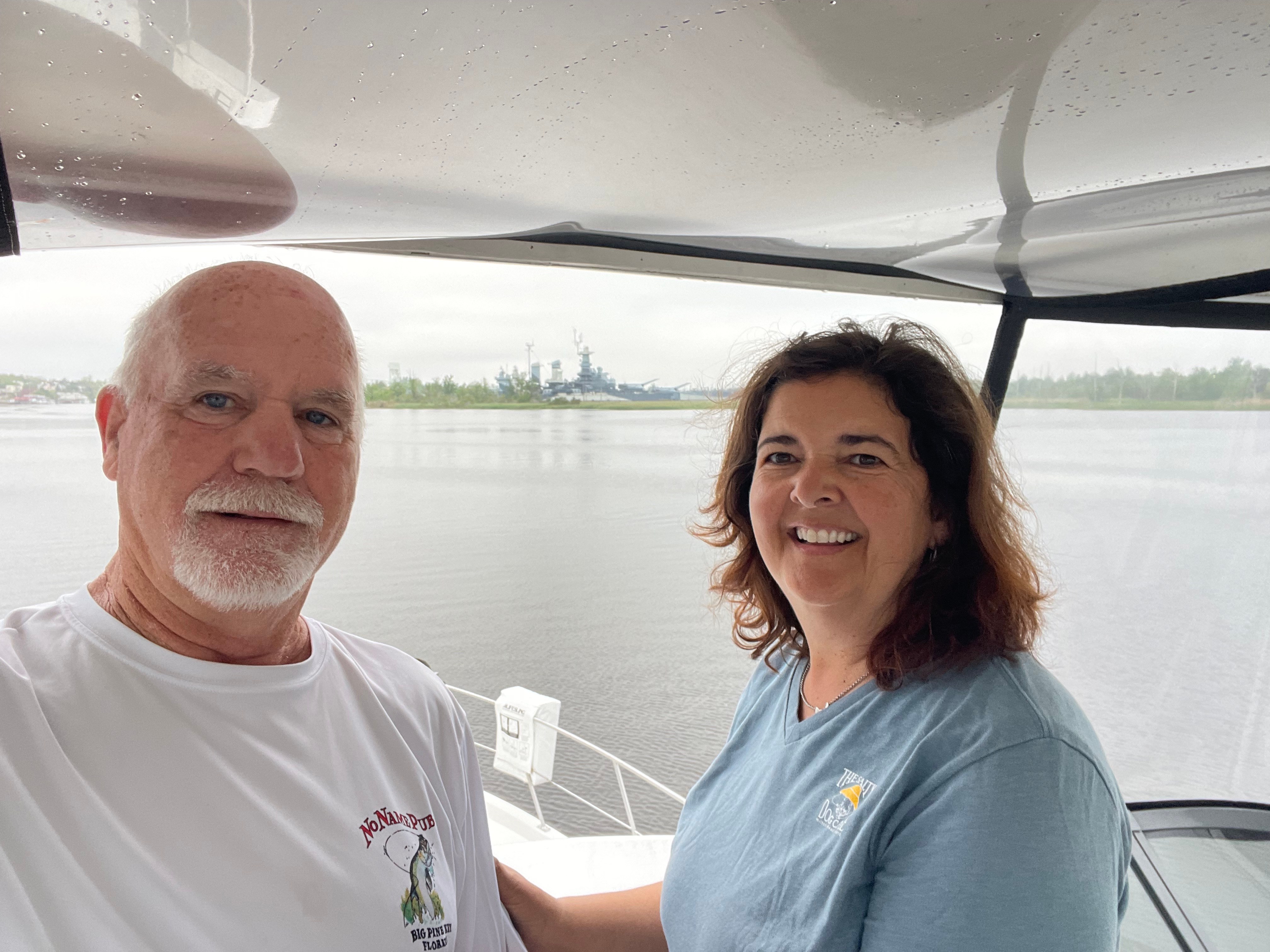
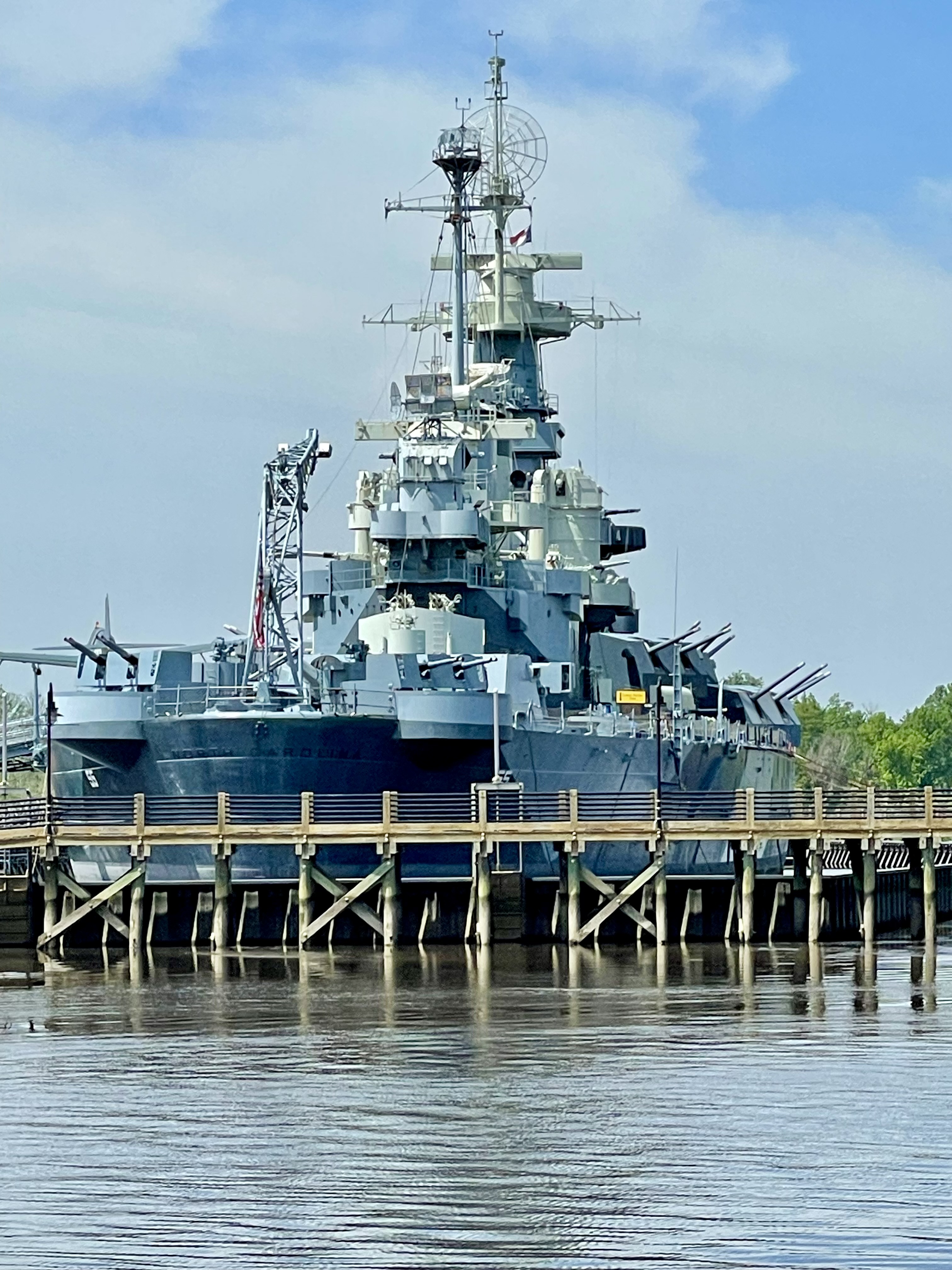
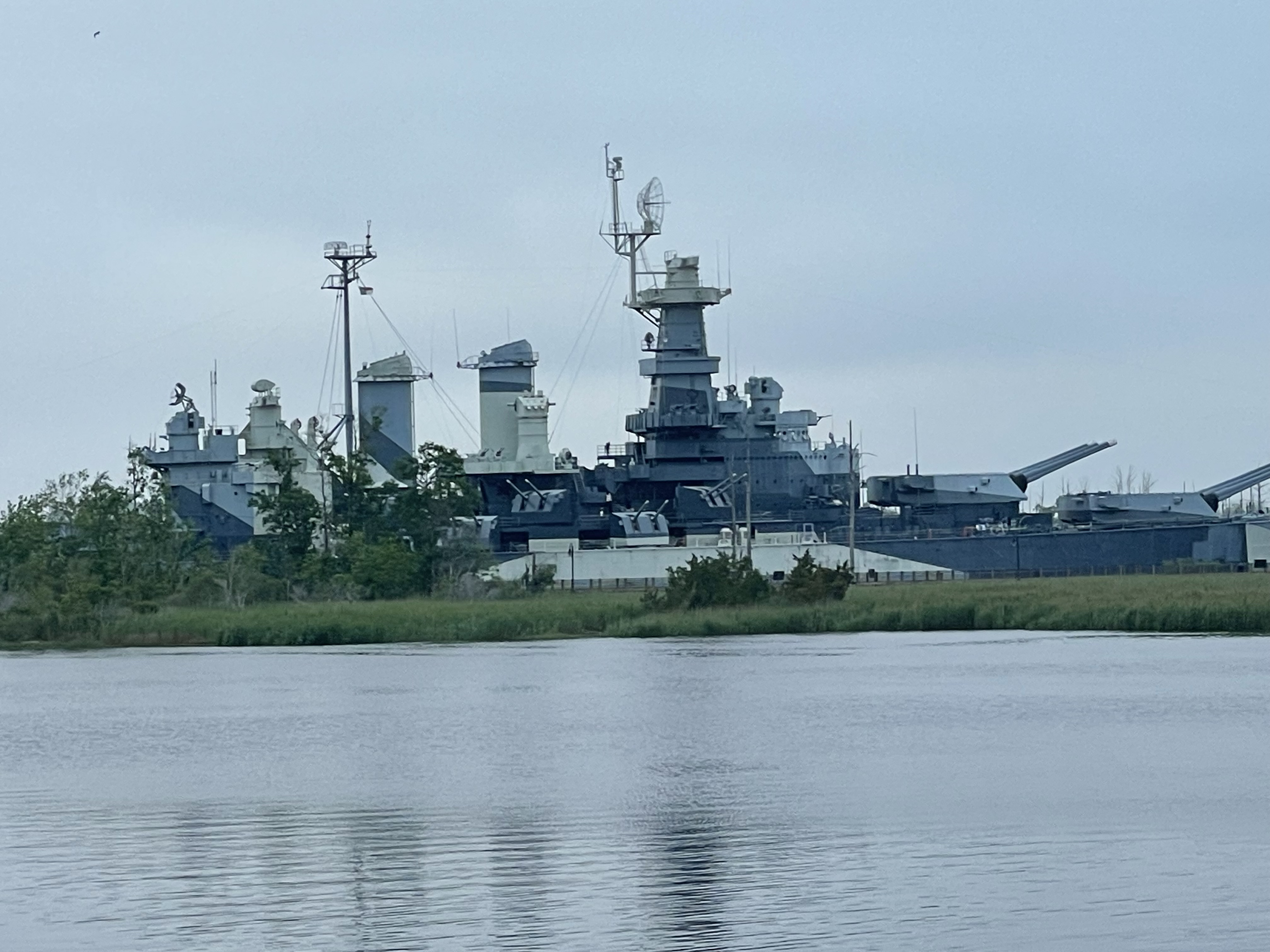
Battleship USS North Carolina on the Cape Fear River
Now or Never docked downtown at Port City Marina, a superb location along the 2-mile riverwalk. We spent a morning at the Wilmington Railroad museum, our captain was like a kid in the candy store soaking in the history and setting all the trains in motion in the model city room.


Train Museum in Wilmington
Jo Ann and Kent gave us a tour of the area and we wrapped up our first night at The Fork ‘N Cork, enjoying the fabulous riverwalk. We traversed the river walk each day, taking in the history of this Colonial port town. Who knew of this hidden gem? So much history. So glad we went straight when the loop path turned right.


Wilmington Art
On our return cruise down the Cape Fear River, just a couple miles out of port, the fog came, dense fog. The Cape Fear is a wide and deep river, so it wasn’t too difficult to navigate in the fog, however, rejoining the ICW near Carolina Beach and a dredge operation that others were having difficulty navigating around, had us rethinking our morning cruise in the fog. We pulled into the Carolina Beach anchorage and dropped anchor. We would spend 15 minutes gathering information and planning our path of navigation. The fog lifted slightly, and we were back on our way with it being clear when we encountered the dredge. Keeping on Bob423 tracks and having listened to the dredge captain correct other boats through the area, we made it through with no alarms. It was nerve-wracking with memories of our last dredge encounter two weeks ago still haunting us. We set anchor at Wrightsville Beach thirty three miles later, by the Masonboro Inlet with about fifty new friends. A large, active anchorage nestled between the beach and ICW.


The Dreded Dredge near Carolina Beach
We’re not sure we’ll ever get used to anchoring in tidal waters and near inlets. There is always a fear your anchor or someone else’s will drag in the middle of the night. The water sounds are exacerbated at slack tide as the water rushes by the hull and landmarks constantly change out the window. The captain always sleeps well. The first mate, some nights she’s too tired to be aware, others she’s on constant watch out the back port window.


Wrightsville Beach with the Lunar Lady Crew
With the anchor set we enjoyed a chilly day on the water with JoAnn and Kent, as they cruised down from their Hampstead home on their skiff and picked us up for a water tour this time and lunch at Wrightsville Beach. Fortunate to be able to explore the area with seasoned tour guides. They dropped us off late afternoon, with just enough time to get home before the rains kicked in. We had a relaxing rainy night at anchor.


Wrightsville Beach, NC
Another early morning departure and long cruise to Morehead City 80 miles north followed. We would pass by Jo Ann and Kent’s intracoastal home that morning on our voyage, they hailed us on the radio, waved as we passed by, and took this awesome photo of Now or Never.


Now or Never from Jo Ann and Kent’s porch (green roof) along the Intracoastal
A beautiful day on the water, we were greeted with sunshine, light winds, and water like glass. A little weary coming into Morehead City after an 8.5 hour day at the helm, the captain was not thrilled with the Saturday traffic. Boats everywhere. This time, all small fishing boats, just anchored in the middle of the channel. Last time we came through it was the week of Big Rock Blue Marlin Tournament, with big sport fish boats everywhere. At the time of our arrival, the big boys were either out fishing or in port having not fished this day.


Morehead City, NC – boats, lots of boats
The rain, wind, and cool temps would follow us and we would wait out weather in Morehead City for a few nights without much incentive to leave the boat. So, like most days, it wouldn’t be a day on a boat without a little boat project, or two, or three.
The captain would spend a day on preventative maintenance on our generator. We haven’t used the generator too much this far but have started anchoring more and preparing for our Canadian summer, it was time. A day crawled up in a ball in a cabinet, not too fun, but with the weather, it gave Dave something to do.
This is a North Carolina port with a BIG fishing problem. Sport Fish everywhere we turned, and with the weather, most were in port. Morehead City and Beaufort hosted 271 boats last year for Big Rock Blue Marlin Tournament and they were gearing up for this year’s tournament, just weeks out. Having tied up in Beaufort twice, we wanted to experience the other side of the bridge and the official host area for Big Rock.


Morehead City, NC – a tribute to Big Rock Blue Marling Tourney
Venturing out on our last day, early week and bad weather, the town was empty. We walked to a marine store, a dog store (old habits die hard), lunch, and the waterfront where all the Big Rock shindigs happen. Temps in the 40’s at night and cool 50’s with wind during the day, we didn’t stay out too long, it was just too chilly. We’re very comfortable hanging out on the aft deck of Now or Never, avoiding the outside weather.
We covered 368 miles during 7 days of cruising through two states. We’re still on target to make Norfolk, VA for our looper rendezvous in early May. Sunnier days are in sight as we prepare to keep cruising north.
Cheers! David, Tasha,
& Remy forever in our hearts!


We sure do miss our girl, Remy
Follow us on facebook for more frequent updates… Mann Aboard
I am always amazed at the complexity of navigating through the rivers. One would think you would just get in a boat and go! But it is a daunting task, for sure. Lessons learned with every post. 😃❤️
Thankful Dave handles most of the research and charting – I get to be the tour director at port! It has been an eye opening experience for us Ohio River boaters.
Such an amazing journey dear Cousin Davey!
I read your skilled writings with such interest.
Thanks of for taking us along.
Love,
Cousin Patty
We’re glad you’re enjoying our adventure a long with us!
As always, so fun to read and imagine your time on the water !! Keep ‘em coming xoxoxo
Thanks Mary.